Ontario’s Blue-Water Lakes
So blue you won’t believe your eyes.
By Virginia Marshall


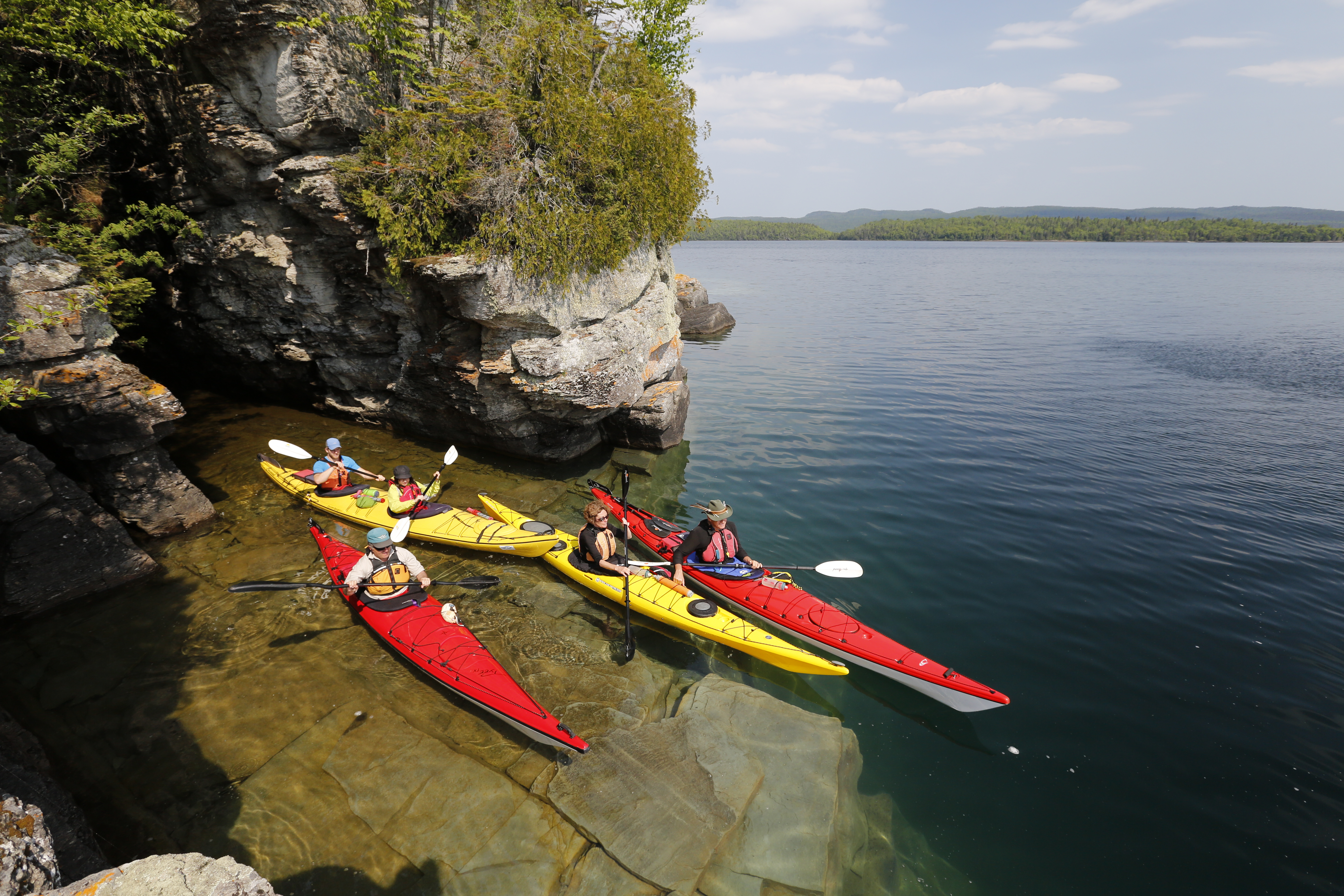
Lake Superior’s freshwater coastline rewards paddlers with unrivalled scenery and solitude. Glide across crystalline waters, touch some of the planet’s oldest rocks, and play lightkeeper at historic lighthouse stations perched among remote offshore islands. The largest lake in the world by surface area, Lake Superior’s tempestuous moods are the stuff of folk legend. But when the lake is placid and calm—as it often is in July and early August—the Lake Superior National Marine Conservation Area promises a paddling experience unlike any other.
Stretching nearly 150 kilometres across the north shore of Lake Superior, this sprawling archipelago of gem-like islands and burnished waters comprises the world’s largest freshwater marine park. Beginning at the foot of the iconic Sleeping Giant east of Thunder Bay, the Lake Superior National Marine Conservation Area reaches past Terrace Bay to encompass hundreds of wilderness islands and countless miles of rugged coastline. Look at a map and you’ll see why this graceful arc of peninsulas and islands is sometimes called the “Whale Tail.”
You could spend two weeks traversing the park end-to-end, or two hours dipping your blade among the sheltered passages of the Rossport Islands. Either way, the vistas are spectacular and the campsites sublime.
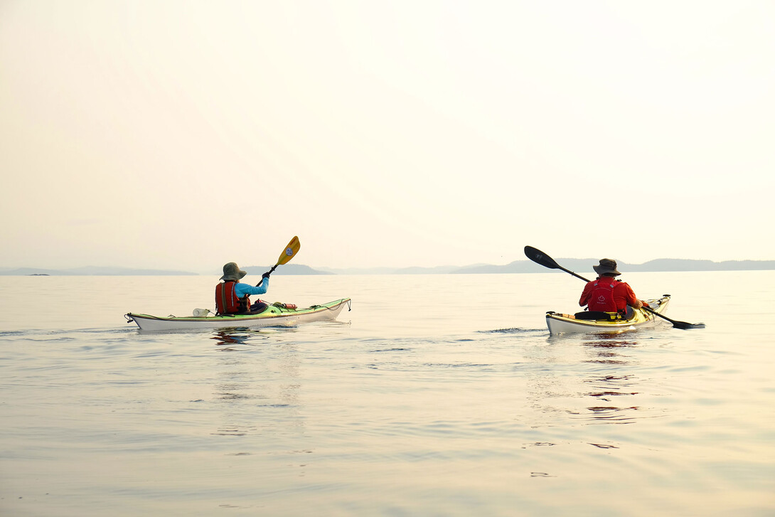
Keep in mind that Superior is no mere lake, it’s a true inland sea with famously frigid waters and the ever-present possibility of ferocious wind and waves. Even in summer, be prepared to enjoy the view from shore one day out of every four. Paddlers who venture onto these waters must be honest about their skills, conservative with decision-making, and keep a close eye on the weather.
Unless you’re an experienced big-water paddler, we recommend booking a guided trip to enjoy these routes safely. Guided trips are also a great way to make a meaningful connection with the area by learning more about Lake Superior’s fascinating natural and cultural history.
Read on to learn more about Lake Superior National Marine Conservation Area routes, camping, outfitters, guided tours and more.
The Lake Superior National Marine Conservation Area is the largest freshwater protected area in the world. Encompassing 10,880 square kilometres (one million hectares) from the mainland shoreline to the international marine border, the park occupies one-eighth of Lake Superior and one-third of the Canadian side of the lake.
Measured end-to-end, it stretches nearly 150 kilometres along the north shore of Lake Superior, from Thunder Cape at the foot of the Sleeping Giant all the way to Bottle Point east of Terrace Bay. Within this protected area are hundreds of wilderness islands, including the second-largest island in Lake Superior.
Protected areas like the Lake Superior National Marine Conservation Area are a critical tool to help conserve fish and wildlife populations, plant communities and freshwater resources.
The protected area includes the lake bed, its overlying freshwater and over 600 islands and shoals. These islands and the mainland shoreline provide habitat for rare and unusual plant species, including Arctic-Alpine disjunct species. They also provide essential breeding areas for Species at Risk, such as peregrine falcons, woodland caribou and American white pelicans, as well as bald eagles and shorebirds.
The cold, clean waters of Lake Superior support incredible biodiversity with over 50 fish species. The Lake Superior National Marine Conservation Area protects the spawning and schooling waters of the rare coaster brook trout and deep coldwater fish such as whitefish, lake herring, walleye, sturgeon and lake trout. The protected area also includes the shallow, warm and highly productive environments of Nipigon and Black bays, which provide important habitat for many fish species that are not typically found at greater depths.
Finally, some of the world’s oldest known rocks—about 2.7 billion years old—and fossils from the earliest periods of life on Earth are protected within the Lake Superior National Marine Conservation Area.
The Lake Superior National Marine Conservation Area is accessible from Trans-Canada Highway 17, which roughly follows the Lake Superior shoreline for the length of the park. Paddlers looking for day trip options will find launches in the communities of Terrace Bay, Schreiber, Rossport, Nipigon, Red Rock and Silver Islet. Keep in mind, however, that much of the NMCA can only be reached by boat or a multiday paddling journey (see below).
Pick up a copy of the excellent Lake Superior National Marine Conservation Area paddler’s guidebook for 10 more great day trip ideas.
Accessible from the quaint village of Rossport—a pretty-as-a-painting hamlet that inspired artworks by the Group of Seven—the scenic Rossport Islands form a compact archipelago packed with natural and historical treasures. The sheltered passages of the inner islands make this a great destination for calm-water kayaking, canoeing and paddleboarding.
Launch from the sandy beach at the east end of the village and tour out to Quarry, Healey, Channel and Wilson islands. Watch the skies for peregrine falcons and bald eagles, take a short hike to a breathtaking lookout, or visit the site where the luxury shipwreck Gunilda rests in Lake Superior’s dark depths. There are also several beautiful campsites within a half-day paddle if you’re looking for a longer excursion.
The new Parks Canada Terrace Bay Beach Pavilion and paddler-friendly launch at the mouth of the Aguasabon River make Terrace Bay a great place to base yourself for day trips along the mainland shoreline of the Lake Superior National Marine Conservation Area.
If the lake is rough, head upriver to see the spectacular Aguasabon Falls and gorge. When the big lake is calm, paddle east to the beautiful sand beaches of Victoria Bay and dramatic rock cliffs at Cape Victoria. Alternatively, kayak west from Terrace Bay along the coast to picnic at pretty Lyda Bay and stretch your legs on the Casque Isles Trail.
Launch from the tiny public beach on Jackfish Lake to access this fascinating historic site on the Lake Superior coast. This day trip is best suited to sea kayaks, since you’ll be paddling the exposed and potentially windy waters of Jackfish Bay. From Jackfish Lake, you’ll paddle through a short tunnel under the Canadian Pacific Railway tracks and enter Tunnel Bay. If you’re lucky, a CPR freight will rumble through while you are here, wrapping around the entirety of the narrow rocky bay and tooting its whistle at the numerous tunnels.
Follow the coast south to a long, terraced pebble beach and land here to explore the ghost town of Jackfish—a 19th-century fishing village that grew to become the largest coal depot for the Lake Superior region when the railway arrived here in 1885. Head uphill to find the remains of the coal dock, water tower and Lakeview Hotel (use caution, this is an active railway).
The kayak-friendly marina in Nipigon provides easy access to the mouth of the Nipigon River and its captivating red rock cliffs. Launch here and paddle south towards Lake Superior, crossing to the cliffs to view a wonderfully preserved panel of centuries-old Indigenous pictographs. This is the second-largest pictograph site on Lake Superior; look for a canoe and depictions of Maymaygwayshi, a mischievous trickster said to live in riverside cliffs on Lake Superior. The Nipigon River is also home to the lake’s largest remnant population of famous “coaster” brook trout—trophy-sized speckled trout prized by anglers.
From the river mouth, return to Nipigon or continue south to the village of Red Rock. A 10-kilometre hiking trail links this sleepy community with the Nipigon marina, offering great Lake Superior vistas and the potential for an adventurous multi-sport day trip.
The classic Silver Islet to Rossport route traverses the heart of the Lake Superior National Marine Conservation Area. Recommended for experienced sea kayakers, this 140-kilometre island-to-island route offers challenging open water crossings and a varied coastline of craggy cliffs and inviting cobble beaches. Highlights include visiting historic lighthouses, rock-hounding remote agate beaches and clambering atop striking volcanic formations of columnar basalt. As if that weren’t enough, you can steam tight trapezius muscles at a smattering of rustic saunas hidden along the boreal shore.
A guided kayak trip is the best way to experience this remote and logistically challenging area. Naturally Superior Adventures’ all-inclusive 10-day trip includes plenty of time for exploration, or choose an all-inclusive eight-day trip with Such A Nice Day Adventures. Less ambitious, boat shuttle-supported itineraries—including a guided five-day kayak trip exploring the Island Nation of Nirivia (the story of this enchanted place is as outlandish as it sounds)—are also possible.
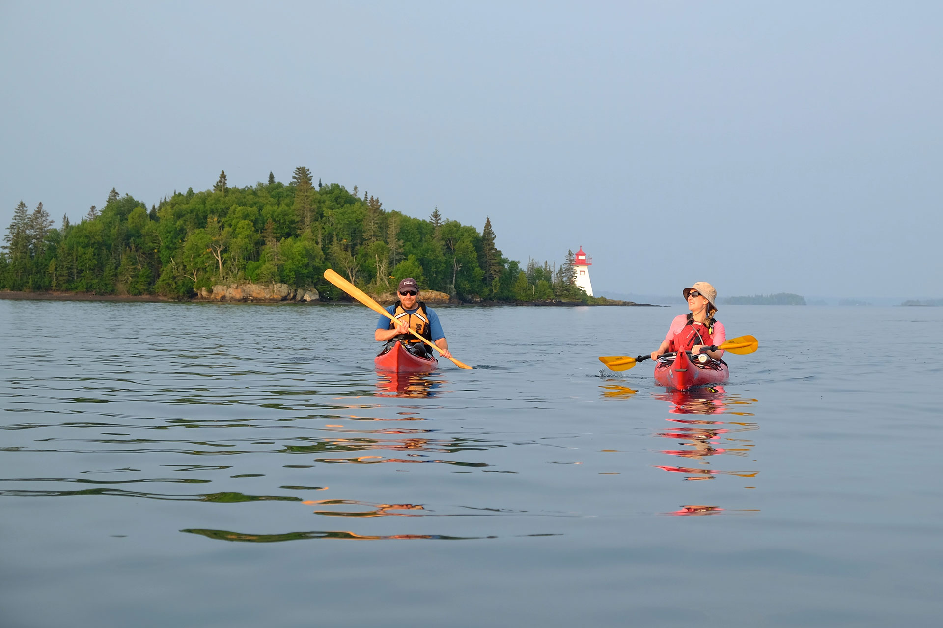
The historic and spectacularly situated Porphyry Island Lighthouse is a popular first stop on many paddlers’ Silver Islet to Rossport itineraries, but it’s also a rewarding destination in its own right. Experienced sea kayakers can make the seven-kilometre open water crossing from Sleeping Giant Provincial Park, east of Silver Islet; or take a boat shuttle to the island and basecamp here to explore the area.
The site is managed by the Canadian Lighthouses of Lake Superior—organization members offer guided tours of the light station beginning with a short walk or cycle up a mossy trail to the 1873 lighthouse. Camp in the harbour or book a stay in the restored lighthouse keeper’s residence; either way, you can end your day with a steamy lakeside sauna and bracing dip.
Such a Nice Day Adventures runs guided four-day Porphyry Island Basecamp trips, complete with sea kayak instruction and boat shuttle to and from the island.
The outermost island in the Rossport archipelago, Battle Island can be visited on a long day trip from the village, but it’s even more enjoyable as an overnight destination. At 22 kilometres round-trip, the distance and exposure make this a tour best suited to intermediate sea kayakers.
Originally built in 1877, Battle Island Lighthouse stands as a sentinel at the eastern entrance to Nipigon Bay. The well-preserved lighthouse is perched high atop a cliff facing the open coast, accessible from a harbour and lichen-draped cart track on the island’s north side. Paddling from Rossport, follow the western shore of Wilson Island and tuck into the protected waters of Chummy’s Harbour before making the crossing to Battle Island.
Anchoring the eastern end of the Lake Superior National Marine Conservation Area, the Slate Islands archipelago offers paddlers a sheltered oasis surrounded by the rolling swells of the mighty lake. Thought to have formed some 450 million years ago from a massive meteorite impact, the islands’ circular arrangement creates a protected inner harbour with peaceful backcountry camping. When the lake is calm, adventurous paddlers can venture around the exposed south coast of Patterson Island to view fascinating rock formations, remote beaches and a spectacularly situated lighthouse.
Lying more than 10 kilometres offshore, boat shuttles make the Slate Islands surprisingly accessible from Terrace Bay. Charter your own, or join a fully supported guided sea kayak trip with Naturally Superior Adventures (six days). Adventurous kayakers who want to tackle the two-hour paddle crossing can book a six-day Slate Islands Expedition with Such A Nice Day Adventures.
The Lake Superior National Marine Conservation Area is a remote, undeveloped and largely wilderness area. There are no entry fees or camping fees, with the exception of certain privately managed sites, like the Porphyry Island Lighthouse.
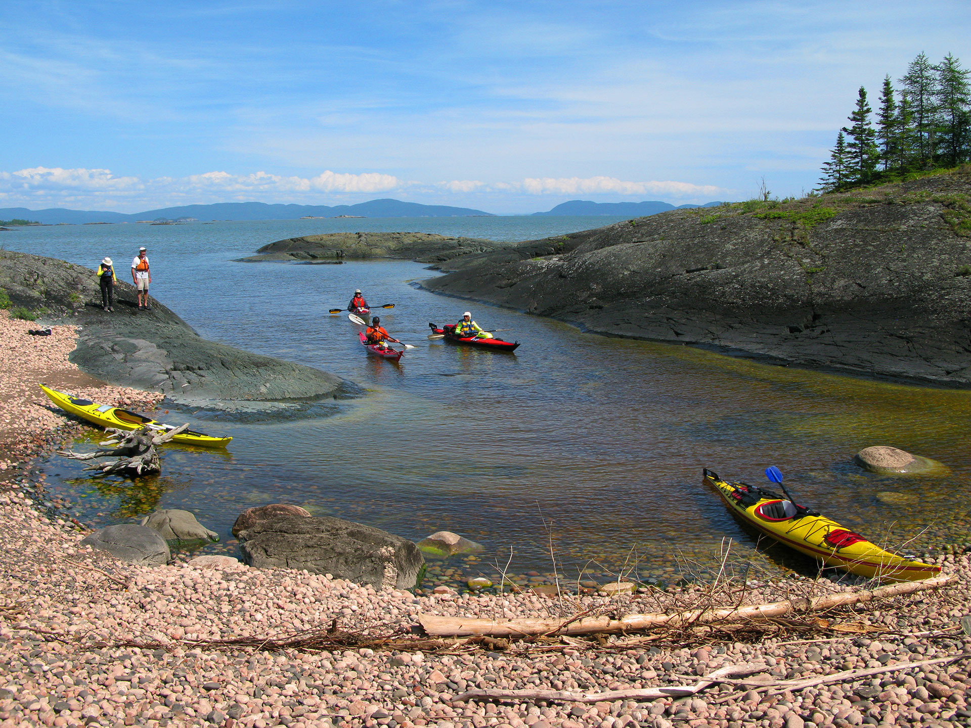
For the most part, campsites are unmarked and undeveloped. Once on the exposed coastline of Lake Superior, paddlers are permitted to land and camp almost anywhere, excluding a small number of private cottage lots and conservation lands. Campers can expect a mix of wild sand and cobble beaches and protected harbours. Many beaches are exposed to open lake swell and require proficiency with surf landing and launching in wavy conditions.
Few places in the world offer such a pristine and spectacular shoreline; practice Leave No Trace camping to minimize impacts to sensitive coastal ecosystems. Avoid having fires in areas that do not contain well established firepits; do not make new rock firepits.
Additionally, three provincial parks exist within the NMCA: Sleeping Giant Provincial Park anchors the western end of the conservation area, Rainbow Falls Provincial Park has a small campground on the Superior shore just east of Rossport, and Slate Islands Provincial Park is a non-operating park in Lake Superior, 12 kilometres south of Terrace Bay. Campers at backcountry sites in Sleeping Giant or vehicle sites in Rainbow Falls are required to pay site fees, either at the gatehouse or online. No fees are charged for camping in the Slate Islands.
To learn more about camping and paddling in the Lake Superior National Marine Conservation Area, pick up a copy of the essential paddler’s guidebook.
These experienced local outfitters make it easy to enjoy a safe and comfortable paddling trip in the Lake Superior National Marine Conservation Area.
Such A Nice Day Adventures founder Zack Kruzins literally wrote the book (with coauthor Darrell Makin) on paddling in the Lake Superior National Marine Conservation Area. S.A.N.D. offers guided day trips and multiday kayak tours throughout the park, as well as sea kayak instruction and rentals from their base in Rossport.
With 30 years of paddling experience on Lake Superior, Naturally Superior Adventures offers guided sea kayak trips, rentals, shuttles, instruction and trip planning assistance. Based in Wawa, their cozy lodge rooms, glamping dome and beachfront campsites are a great way to break up the long drive north.
A wonderful diversity of shoreline habitats makes the Lake Superior National Marine Conservation Area a refuge for many boreal forest birds and mammals. Moose, black bear, bald eagles, beaver, hare, fox, otter and wolves call this coastline home. These remote and secluded islands also provide critical habitat for several Species at Risk, including peregrine falcons and woodland caribou.
Paddle into marshy bays on St. Ignace Island to search for moose and shorebirds; keep an eye out for black bears at river mouths along the mainland; and look for otters and bald eagles anywhere along the shoreline. Peregrine falcons nest and hunt from coastal cliffs—you’re likely to spot these aerial acrobats at Quarry Island near Rossport and Cape Victoria near Terrace Bay. The Thunder Cape Bird Observatory is located right on the edge of the NMCA near Silver Islet; visit in spring or late summer to learn about the hundreds of breeding and migratory bird species found here.
The Slate Islands once held the largest concentration of non-predated woodland caribou in the world. Today their population is small but growing; search for caribou signs such as hair, scat or tracks throughout the Slate Islands’ inner harbour.
It should come as no surprise that the world’s largest freshwater protected area offers an abundance of rewarding angling opportunities. Whether you’re fly fishing, spin casting or trolling behind your kayak, you’ll find spring and summer waters teeming with fish.
Popular sport fish include brook and lake trout, steelhead, coho and pink salmon, northern pike, walleye/pickerel and yellow perch. Target mainland river mouths for steelhead (rainbow trout) early in the season and for salmon in the fall.
Lake Superior is also famous for its unique population of “coaster” brook trout. Coasters typically spend part of their lives in the big lake, then migrate back to tributary streams, estuaries, or near-shore locations in the late summer and early fall to spawn. Much larger than other brook trout, coasters are a prized catch for anglers from around the world. The mouth of the Nipigon River, Nipigon Bay and the waters surrounding St. Ignace Island offer excellent fishing for record-sized coasters, as well as trophy lake trout.
Ontario provincial fishing regulations apply throughout the marine conservation area.
Lake Superior remains cold—less than 10 degrees Celsius—all summer, and wind and waves can develop quickly, making travel impossible. Independent paddlers venturing into the remote islands of the Lake Superior National Marine Conservation Area require well-developed open water paddling, self-rescue and navigation skills. A flexible schedule, good judgment, and knowledge of wind and weather patterns are also essential.
Early summer (late June to early August) offers the calmest conditions, but even so, be prepared to enjoy the view from shore one day out of every four. All paddlers on these frigid waters need proper immersion clothing, such as a wetsuit or drysuit, as well as a reliable means of satellite communication (SPOT or inReach device). A seaworthy touring kayak with sealed hatches and bulkheads is also a must.
We highly recommend booking a guided trip to enjoy these routes safely. Guided trips are also an amazing way to make a meaningful connection with the area by learning more about Lake Superior’s fascinating natural and cultural history. Plus, you’re guaranteed great campsites, tasty food and memorable stories!