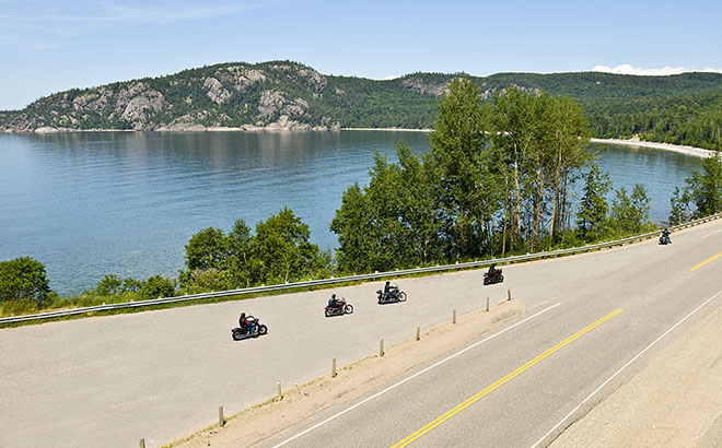

Aubrey Falls
Retrace Tom Thomson’s Canvas
By Sheri Minardi


Helmet acoustics are fabulous, I thought to myself, and continued to sing aloud Gordon Lightfoot's "Wreck of the Edmund Fitzgerald". Though it's a tragic tale of loss, I enjoyed its catchy melody. I lifted my toe in sync with the song's rhythm, tipping the Triumph into sixth gear and still further along the wood-lined road to its hilltop.
I rode on past the parking lot and along the footpath to the monument's base. I turned off the bike, dismounted and walked toward the towering one-legged bronze man, runner Terry Fox. It was here, 18 miles from Thunder Bay in 1980, that his Great Marathon of Hope ended. I walked over to the lookout deck and to the panorama of Lake Superior and Thunder Bay. I could see from where I'd ridden and to where I'd ride.

This was the furthest North in Ontario I had ridden. Sault Ste. Marie-Algoma awakened before my window's view. The rain from the night before was gone, replaced by a flawlessly sunny riding day for my "Ride Lake Superior" coastal tour. I'd had one of those deep Northern sleeps in the large suite of the Days Inn & Suites and used its fireplace to dry my wet socks. The new Triumph Street-Triple was left to dry itself in the covered motorcycle parking area.
Up and over the International Bridge, and crossing St. Marys River from Sault Ste. Marie, Canada gave a grandstand overview of both shores to its American "Soo" sister, with even the Bushplane Museum I'd visited earlier that morning. Now leaning over a full tank of America's inexpensive fuel, I headed toward the lake's shores. The scenery transformed from the city to the farm, to Superior's coast. I pulled into the Point Iroquois Light Station, seizing my first, official sighting of Lake Superior – so mighty, I thought as I gazed upon its blue sparkling horizon.
Riding ever westward along its shores, not only the lake's glittering views held my attention, but also the fault-free surface of its winding roads! The Triumph bowed as Highway 123 left the shore and twisted back through the illuminated emerald greens of Tahquamenon Falls State Park. Shortly, the woods opened to the glistening blonde sands of Grand Marais extending for miles along the lake's beaches.
Travelling further, I arrived in Houghton, overlooking the Portage Canal. Its old red sandstone buildings lined its tightly-packed small business district. I had many thrills manoeuvring through its steep one-way streets! After dinner at Joey's Seafood Restaurant & Grill, I headed to the Holiday Inn Express for the night.

Northbound on Highway 41/26 to Copper Harbor, once through the town of Mohawk, the road narrowed and broke away. The trees were close and closer than ever before. I couldn't help but ride faster to take it all in. My eyes moved over every blind hill and around every corner. Sooner than for most, the road opened up, arriving at Copper Harbor. Noted! I added this road to my personal list of favourite motorcycle roads.
Highway 41 ends or begins, depending on which way you're travelling, just east of the Fort Wilkins State Park – a historic site and campground. And following it from here brings you all the way to Miami! I rode it west again and away from Copper Harbor. I veered off the standard route, turning left onto Brockway Mountain Road – to its mountain top! It was a "B Class" road, or perhaps "C"! Upward I went on its uneven, jumpy surface with bouts of gravel and some extremely vertical sections, which could not have pleased me more!
The road eventually peaked. I had reached the top, climbing 1,328 feet (404 m) above sea level, and 726 feet (221 m) over Lake Superior! Far and wide, Superior's majestic blue could be seen. Later, it would reflect a most spectacular Copper Harbor sunset, and I wished I could have stayed to see that!

Brockway Mountain road descent reconnected me to Highway 26 westward. Four hours later, I arrived in Bayfield and the Bayfield Inn, my stay for the night. It was long past dinner time – even after gaining an hour crossing into the Central Time Zone! I threw on my blue jeans and walked up the street for dinner. Seated under the dangling collection of pink flamingos from the ceiling above in the restaurant, Tiny, the restaurant's chef, joined me and shared his recommended favourite dessert: a homemade ice cream sampler!

No way could I pass up this farmer's fresh local cherries from his parked farm truck in the Inn's lot. I stuffed a small bag into my already over-packed tank case for later. I rode out and down the street to view the Apostle Islands Info Centre and their film about the twenty-two Islands just offshore. I chuckled, looking around in the filming room with everyone in their kayaking gear and me in full moto gear!

The hours, the wind, and the road contentedly whisked me along Lake Superior's shores. I couldn't resist stopping at its many beautiful scenic outlooks, including some of Superior's 56 lighthouses! Highway 13 led me away from the coast and through the wooded greens of the countryside, eventually to be joined by Freeway 53 crossing the Blatnik Bridge. Here I left Wisconsin for Minnesota.

Gene, Duluth's tourism expert and Randy of Aerostitch Rider wear, awaited my arrival for a tour of Aerostitch's World headquarters. Onto my hotel, the Canal Park Lodge, a quick change of clothing and an unsuccessful attempt to tidy up my helmet hair, I rejoined Gene with his wife at the South Pier Grandma's Saloon & Grill for dinner. From the restaurant's outdoor rooftop deck, we toasted Duluth's sunset and the illuminated Ariel Lift Bridge, one of the city's landmarks.

An hour north on Highway 61 out of Duluth, the spa-type resorts and cabins faded to woods and water. I enjoyed a visit to one of Lake Superior's most popular scenes, located along this stretch: the Split Rock Lighthouse. It's one of the most photographed lighthouses in the U.S.A., towering on craggy cliffs 40 metres above the lake.

Returning through the Canadian border crossing and simultaneously winding ahead to Eastern Standard Time, Canada's wilds stepped forward. The woods grew denser, and road signs with moose warnings became more frequent. Towns were few and far between, and I had to keep a close watch on my fuel supply. Inhaling the woods, water, and old stone in this wilderness made me somewhat complacent, but I knew I had to keep up a good pace to make it to Thunder Bay before nightfall.
Thunder Bay's newly designed Waterfront District reminded me of Sweden's Stockholm harbour with its contemporary architecture, Euro-styled bistros and cafés. Now riding eastward with the legendary Sleeping Giant and its Provincial Park disappearing behind me, Superior begins to run free. Its shoreline, stronger and rockier, was edging me along Trans Canada Highway 11 northeasterly while cutting through some of the lake's most deserted sections.

Before leaving Thunder Bay behind completely, riders should know the city has a must-stop attraction: the Kisselgoff Motorcycle Museum. Located inside a restored 1940s theatre, it showcases vintage bikes, memorabilia, and local moto history—a perfect cultural pause before heading deeper into Superior Country.
Past Eldorado Beach, the road turned further away from the lake's coast. I passed over the Nipigon River, marking Lake Superior's most northerly point. The ride forward now was southward, passing Terrace Bay and its thundering Aguasabon Falls and then the town of Marathon.
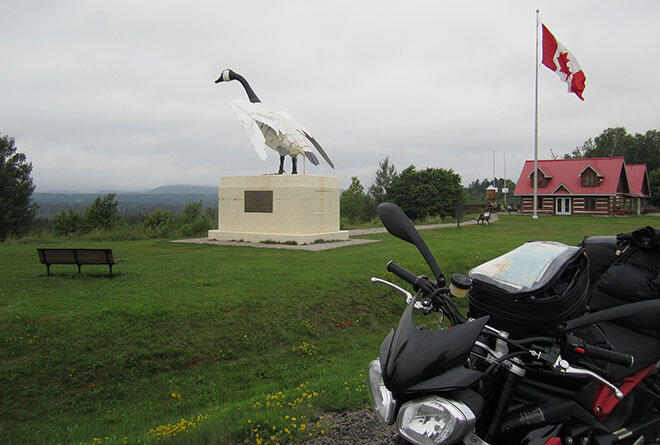
Highway 17 now curved eastward, the woods closed in, hugging the road, and the cautionary moose warning signs were more frequent. A few more hours later, and there it was in black and white: Wawa's famed gigantic Canada goose! I rode closer and captured my own goose photo memento. The nearing threat of rain and nightfall signalled the ending of another "Superior" day. I rode to the Best Northern Motel & Restaurant for a hot meal in its family-run eatery, and a Wawa good night's stay.

The wind was a little chillier now, and the skies a little darker. It was as though Superior disapproved of our final day together. Feeling a sense of accomplishment, I headed east on Trans Canada 17, the completion of my Lake Superior circle ride. I stopped at Old Woman Bay, followed by Agawa Rock and later Lake Superior Provincial Park Interpretive Centre. I continued until reaching Agawa Crafts and the Canadian Carver, and also one of the few fuel stations to be found.

Superior grew shallower as its southern body narrowed and neared the road. Here, the highway would lead me inland to Sault Ste. Marie. I looked over my shoulder at Lake Superior's waters with one final admiring gaze before I rejoined the roads of civilization. Reluctantly, I turned to the road ahead, twisted the throttle and began to sing –"...the big lake they call Gitche Gumee!"