SUP in the city
The top 6 places to paddleboard in Toronto.
By Diana Lee


Killarney Provincial Park is considered a crown jewel park in Ontario. Many of the special, remote places located within the park boundary are only accessible by hiking along and in between mountain ranges, or by canoeing and portaging across pristine lakes and well-worn, but sometimes challenging, portage trails.
Located on the coast of Georgian Bay, about 400 kilometres northwest of Toronto and 100 kilometres southwest of Sudbury, Killarney presents a landscape that can’t be found anywhere else in Ontario. With its ridges lined with white quartzite rock and truly turquoise-coloured lakes, Killarney is without question a sight for sore eyes. While hiking in Killarney, you’ll feel as if you are walking through a Group of Seven painting. In fact, several of the artists painted in the park, including Franklin Carmichael and A.Y. Jackson, who have lakes named after them.
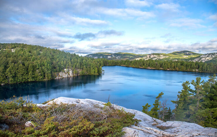
Most sites on the La Cloche trail have lake access, resulting in beautiful evening views such as this one. Source: Hailey Sonntag // @WildCanoes
You don’t have to hike far to take in incredible views, either. There are many day hiking opportunities within the park, of varying levels of difficulty. For those wishing to sincerely immerse themselves in Killarney’s magical landscape, there’s of course the La Cloche Silhouette Trail—the rugged backpacking trail that draws so many to the park. This guide to Killarney hikes will help you plan your trip to this iconic Ontarian destination.
Hailey at the iconic lookout from the top of The Crack trail. Source: Hailey Sonntag // @WildCanoes
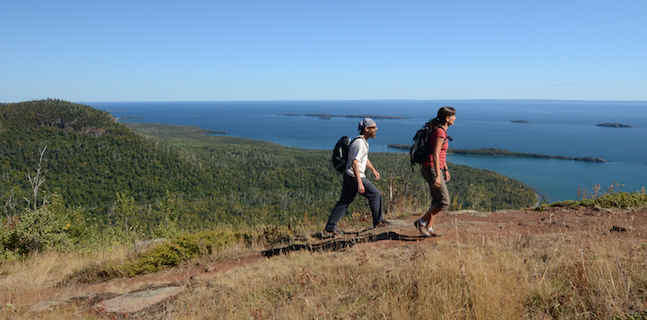
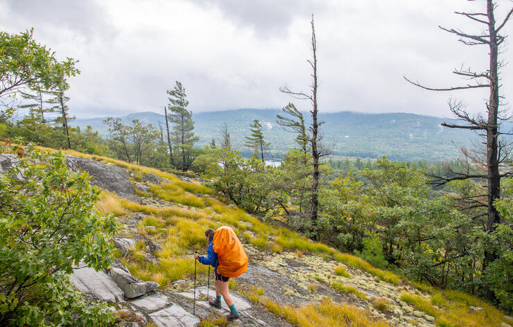
The Crack is a must-hike trail when visiting Killarney Provincial Park and is one of the most popular hiking trails in Killarney. Its difficulty level falls on the moderate to challenging end of the scale, depending on your fitness level and capabilities. The trail starts on an old logging road and eventually meets up with the La Cloche Silhouette trail. You’ll hike through forest and up a couple steep, rocky climbs, before emerging into the open and onto white quartzite rock. From here, the hike leads up and through The Crack itself—a deep crevasse between two massive rock walls. Make sure to follow the blue markers along the way, and be mindful of where you step. Once at the top, you’ll be rewarded with a picturesque view of Killarney Lake and O.S.A. Lake nestled in the La Cloche mountain range. It’s recommended you wear proper hiking footwear and bring snacks and hydration on this hike.
On average it takes three to five hours round-trip to hike The Crack, depending on your pace and the weather conditions. For example, when it's raining you are usually forced to slow down as the rocks become slippery. This is an out and back trail and is 6 kilometres total, which doesn’t seem like much, but with the elevation changes it can feel like a lot more!
The Crack’s highest point of elevation is roughly 355 metres or 1,165 feet, allowing you to get a beautiful panoramic view of everything around and down below.
To access this iconic Killarney hiking trail from the George Lake campground office, drive east on Highway 637 (the opposite way you drove in) for 7 kilometres. The trailhead is located on the north side of the road. If you’ve booked a stay at the campground, your vehicle permit will allow you to park at the trailhead. Otherwise you can purchase a day pass using the available kiosk.
Granite Ridge is a simple yet stunning hike in Killarney. This trail takes you through an old planted forest, past remnants of a rusty car, and up to two lookouts with stunning views of Georgian Bay and the La Cloche range. This hiking trail remains a favourite as it perfectly showcases what the area has to offer and is a primer for the vast landscapes you will encounter while exploring the rest of the park.
This loop trail is only 2 kilometres long and, when hiking at a moderate pace, can be completed in about an hour. You’ll definitely want to give yourself some time to stop and take photos while on top of the ridge as the scenery is absolutely gorgeous!
The Granite Ridge trailhead is located right across the road from the George Lake campground office. The parking lot at this trail is relatively small and many campers opt to safely cross the road and walk to start the trail instead of driving.
The Cranberry Bog trail is located in George Lake campground and takes you through some of the different landscapes in the park. It ranks as moderate on the trail difficulty scale. Starting out, you’ll hike through Proulx Marsh before continuing through multiple bogs, marshes and swamps. Eventually you’ll make your way to A.Y. Jackson Lake, which features, as its name suggests, gorgeous Group Of Seven-like views.
Cranberry Bog is a 4-kilometre loop and, when walking at a moderate pace, takes two to 2.5 hours to complete.
This trail is located in the George Lake campground, which makes it a perfect hike if you're camping there already. You can find the trailhead between campsites 101 and 102. There is a small parking lot at the bottom of the hill just to the left of site 101, if needed.
The Chikanishing Trail highlights the pink, granite, rolling rocks Killarney has to offer, and provides stunning views of Georgian Bay and Phillip Edward Island across the channel. Although this trail is short, it's one of the most popular Killarney hiking trails. This trail isn’t particularly difficult; however, there are some small elevation changes that bump its rank on the difficulty scale up to moderate. Be careful walking on the rocks after rain as they can be very slippery.
This trail is a 2-kilometre loop and will take 1.5 to two hours depending on your pace and how often you stop to take in the beautiful scenery.
The road to the Chikanishing trailhead is located 2 kilometres west of the George Lake campground on the south side of Highway 637. After turning off the highway, you’ll follow a bumpy and winding road to a parking lot near the trailhead. The road does narrow often, so be sure to travel at a safe speed and leave room for others passing by.
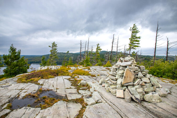
Most trails in Killarney will take you over white quartzite rocks. Source: Hailey Sonntag // @wildcanoes
The Lake of the Woods Trail features diverse landscapes and is a great place to escape the busy crowds you may find along The Crack and other Killarney Provincial Park hiking trails. This trail ranks as moderate; there are some elevation changes and steep sections, but nothing overly strenuous. You’ll walk through old forests and be rewarded with amazing views of Silver Peak as you walk out onto typical Killarney ridges.
The Lake of the Woods trail is a 3.5-kilometre loop that takes approximately three hours to complete.
This trail can be accessed via Bell Lake Road, which is located east of the George Lake campground and on the north side of Highway 637. This road is extremely bumpy and uneven, so please drive accordingly. After about 7 kilometres on the road, you’ll come to a small parking lot at the Turbid Lake access point on your right. The Lake of the Woods trailhead is located across the road from the parking area.
Silver Peak is the highest ridge in Killarney Provincial Park and offers stunning views of the surrounding ridges and lakes—you can even see the Sudbury smokestacks on a clear day. The trail up to Silver Peak is a side trail on the La Cloche Silhouette backpacking trail. Those hiking the full La Cloche Silhouette can choose whether to make the trip up to Silver Peak or continue on.
Those wishing to visit Silver Peak on a day hike will need to canoe to the Silver Peak trailhead. This trail links up with the La Cloche Silhouette and is mostly flat—until you get to the base of Silver Peak. Then it is one giant elevation change, making hiking in sturdy shoes a must.
The paddle to the dock at the beginning of the Silver Peak trail is 3 kilometres long and should take less than 30 minutes on a day with average wind. The hike from the dock up to the top of Silver Peak is 5.5 kilometres. As a round trip, you are looking at roughly 11 kilometres of hiking and 6 kilometres of paddling. This will most likely be an all-day adventure, so you’ll want to plan accordingly by allowing yourself enough time to finish in daylight.
The most common way to access the Silver Peak hiking trail is to start at the Bell Lake access point, located at the end of Bell Lake Road (east of the George Lake campground and on the north side of Highway 637). From here, you’ll paddle north and then west to the end of Bell Lake where the dock at the trailhead is located. Bring your own canoe or rent one from Killarney Kanoes, located at the Bell Lake access point. After reaching the dock, you’ll then follow a flat trail to the La Cloche Silhouette trail, which will take you to the base of Silver Peak where you’ll begin a strenuous hike up.
If camping on one of the canoe-in sites on David or Boundary Lake, you can access the Lake Cloche Silhouette trail byway of the portage between David and Boundary and take it to the base of Silver Peak. As mentioned, if you are hiking the La Cloche Silhouette trail in full, you’ll pass by the trail up to Silver Peak on the eastern portion of the loop.
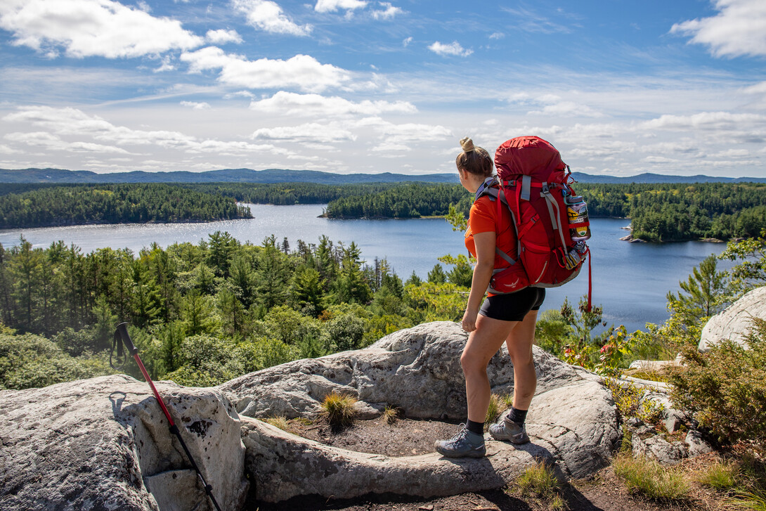
The view over Little Superior Lake is one of the most beautiful lookouts from the La Cloche Silhouette trail. Source: Hailey Sonntag // @wildcanoes
The La Cloche Silhouette Trail is a multi-day backpacking trail that is ranked as difficult—however, the views are extremely rewarding and make every step worth it. The distance of the trail is marked as 100 kilometres at the posts at either end of the trail, but the distance varies depending how far off the trail your campsites are.
Once you have decided you’d like to give the La Cloche Silhouette a go, the next step is picking the direction you’ll hike the trail. Many people opt to hike the trail clockwise. By hiking this way, you’ll start off with few elevation changes and nothing crazy in the terrain department, giving you a day or two (depending on your trip length) to ease into the rougher terrain and bigger ascents.
Counterclockwise offers the opposite; you’ll get many of the steeper ascents and descents done right off the bat. People may prefer this as their legs will be fresh, but the downside is that your pack is heavier as you haven’t eaten much food yet. It’s a personal preference thing and each way has its pros and cons.
Take the hassle out of planning your hike with Killarney Outfitters, who offer complete day and multi-day backpacking trip planning and outfitting services (finest equipment and meals).
Campsites are positioned at various places along the trail. In many cases, you’ll need to hike down a short side trail to reach the site you’ve booked for that night. All sites have a thunderbox and a firepit. Every campsite has water access, most in the form of a lake with the exception of H23, which has creek access (note that in dry/hot weather, the creek can dry up).
There are campsites at most lakes along the trail, so the distance between each site you stay at depends on what you book. Most campsites have at least one flat spot where you can pitch your tent, although I’m not making any promises! Let’s just say you’ll find more not-flat spots than flat spots.
You can book your campsites online or over the phone (1-888-ONT-PARK /1-888-668-7275). Before booking your sites, however, you should look at a map and plan out the approximate distances you want to travel each day. Keep this map out while you are booking as well, to ensure you are staying within range of these distances.
Hiking the trail requires you to book each campsite you plan to stay on in advance, unlike backcountry canoe camping where you can choose any available site based on the lake you reserve. If you aren’t able to make it to your campsite for the night, you will be forced to camp just off the trail. The negatives to this are that you may not have water access and there will be no designated toilet. If you find yourself in this situation, I recommend you don’t have a campfire as there is no firepit. As well, be sure to dig holes to use to do your business.
Lumsden Lake showcases Killarney’s towering cliffs and windswept pines. Source: @WildCanoes
Most guides say the trail takes seven to 10 days to hike. Experienced backpackers can certainly complete it in less time—how many days you choose to spend on the trail will largely depend on how far you are capable of hiking in a day, but also how much downtime you want to spend at campsites and taking in views.
When figuring out how many days to hike the trail in, there are a couple things you should consider. First, you should decide how far you want to hike each day by taking a look at the distances between campsites on a Killarney hiking map. Next, you should head to the reservation site and see what campsites are available for the approximate dates of your trip, as this may change how much you’ll be hiking each day.
Once you have a route planned out and booked, it may be wise to do some training. You may also want to pre-pack your bag to see how all the gear fits and how much weight you’ll be hiking with on your back.
Following are suggestions for trip itineraries based on common trip lengths:
If you were to hike the trail in five days and four nights, this is a potential route that roughly divides the trail in quarters. In terms of distance, this itinerary involves hiking 13 to 20 kilometres per day (rough estimate may not include elevation gain).
If you were to hike the trail in seven days and six nights, you’ll likely be hiking 9 to 12 kilometres per day (rough estimate may not include elevation gains).
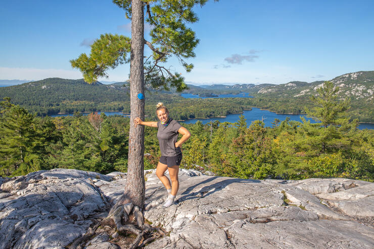
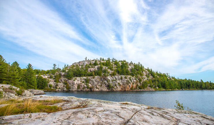
Although Killarney’s landscape is very different from elsewhere in the province, it varies greatly even within the bounds of the park. Source: Hailey Sonntag // @wildcanoes
A great first taste of the trail could be accomplished by starting the trail clockwise from the George Lake campground and hiking into H7 at Topaz Lake. Although I’d recommend this as an overnighter trip on the trail, it could be done in a day. Topaz Lake is the first real “gem lake” on the trail, so booking the site on the lake can be particularly difficult.
The La Cloche Silhouette trail markers are blue for trail portions and red to mark campsite trails. When hiking to Topaz Lake, follow the blue markers until halfway up what is known as “The Pig” portage, at which point you should start following red campsite markers. If you have reserved H7 on Topaz for the night, continue following the red markers around the lake to your site.
Site H7 on Topaz Lake is highly sought-after. Source: Hailey Sonntag // @WildCanoes
If you decide to do this 21-kilometre out and back hike in a single day, follow the red markers until your first glimpse of Topaz at the top of a hill. From there, you can follow other trails leading down to the water and find a place to enjoy your time on Topaz. Please respect the campers on H7 and avoid following the red markers into their campsite.
Day hikers should come prepared with water (and a way to purify water, if need be), lots of snacks and a good pair of hiking boots. This section hike will give you a small idea of what the trail is like and makes for a good introduction to the La Cloche Silhouette trail.
At around 100 kilometres and with many steep ascents and descents, you’ll want to pack light on the La Cloche Silhouette trail. Source: Hailey Sonntag // @wildcanoes
As Killarney is such a small town, the only outdoors store in the area is Killarney Outfitters. It’s located just five minutes west of Killarney Provincial Park and on the north side of Highway 637. It’s the perfect place to go if you want to rent a canoe, kayak, or SUP, forget something, run out of fuel, or just want some ice cream.
If you plan on hiking the La Cloche Silhouette trail, Killarney Outfitters can set you up with all the gear and food you need, as well as help you plan your route with a Killarney backcountry hiking map and/or book your hike. If paddling to a trailhead, renting from Killarney Outfitters is an easy and stress-free process, and includes your boat of choice, life jackets, a safety kit and paddles.
Located at the Bell Lake access point, Killarney Kanoes offers canoe and kayak rentals delivered to the major access points along Highway 637.
There are currently no guided trips offered on the La Cloche Silhouette trail in Killarney.
For more information regarding Killarney hiking trails, please contact Killarney Provincial Park or Killarney Outfitters (outfitting services).
The official Ontario Parks map of Killarney Provincial Park trails can be purchased at the park store, located at the George Lake campground. Second-party maps can be purchased at Killarney Outfitters. Procuring multiple maps can sometimes give you a better idea of what you’re working with as you’ll get several different points of view.
Please note that in Killarney Provincial Park’s trail guide, estimated distances along the La Cloche Silhouette trail do not include elevation gains.
If staying at Killarney Provincial Park, there are options for campsites and roofed accommodations. Backcountry canoe-in sites are reserved by lake, while backcountry hike-in sites are reserved by site. Frontcountry sites are also available, but know that there are no electrical sites in the park. The provincial park also has cabins and yurts to offer.
All sites and roofed accommodations can be booked online through the Ontario Parks online reservation system. You can also reserve over the phone: 1-888-ONT-PARK (1-888-668-7275).
Don’t want to rough it? Book a room at the Killarney Mountain Lodge, located in the nearby town of Killarney. Enjoy onsite dining, excursion planning services and beautiful facilities.
Choose between a private cabin, private balcony suite, shared balcony suite or motel room at the Sportsman’s Inn & Marina. This resort is also located in the town of Killarney and offers onsite dining, marina services, a pool, a sauna and more.
Take some time to unplug by renting a waterfront cabin at Avalon Eco Resort. Located east of the provincial park, this resort has onsite canoeing and hiking trails.
The Killarney East Lighthouse is located down Ontario Street in Killarney, which is your first left when heading into town. The road is in pretty rough shape, so please use it at your own risk. The actual hike to the lighthouse is along an old road and is less than a five-minute walk. The lighthouse looks out to Georgian Bay where you can see Phillip Edward Island, George Island and even Manitoulin in the distance.
First Nation owned and operated, Point Grondine Park provides even more wilderness to explore including water and hiking trails. The park also offers guided experiences that focus on natural education and insight into Anishnaabek culture.
Herbert Fisheries boasts world-famous fish and chips, right in the town of Killarney. To find it, drive to the end of the road on Highway 637—you can’t miss it!
Aunt Bea’s Corner Kitchen is located right across from Herbert Fisheries—you’ll see the blue and yellow chip truck! It has some of the best food in town, in my opinion. Whether you're looking for a hamburger, poutine, corn dog or onion rings, they have it all and with affordable pricing.
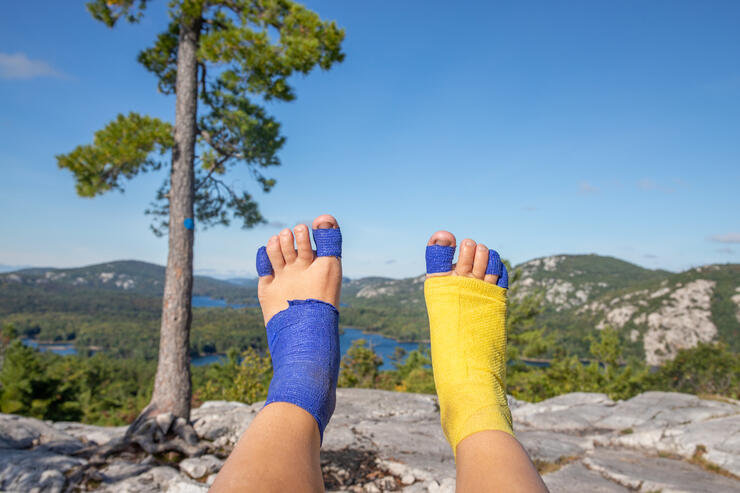
Hailey’s feet after eight days of hiking the La Cloche Silhouette trail. Source: Hailey Sonntag // @wildcanoes
If I’m being completely honest, I really don’t have a favourite campsite along the La Cloche Silhouette trail. My feet are famous for getting blisters regardless of how broken-in my boots are or what socks I’m wearing, so at the end of the day wherever we stop is my favourite campsite!
H7 on Topaz Lake is a hard-to-book favourite for many. The white quartzite cliffs and turquoise waters are a real treat, especially if you're hiking in the summer and can enjoy a swim. Another lake I enjoy staying on is Three Narrows Lake—any of the sites on that lake are beautiful, although the trek into H19 seems never-ending.
Little Superior Lake is absolutely stunning, although I’ve never had the opportunity to book the campsite on it; I can only imagine it’s just as gorgeous as the rest of the lake's scenery.
There are so many dazzling sights to see along the La Cloche Silhouette trail, but my hands-down favourite is the lookout at the top of Three Narrows Lake. You’re treated with several lookouts throughout the Three Narrows Lake section, all of which are incredibly rewarding. However, hiking up the ridge to the highest lookout will provide you with a panoramic view of everything around and below making this, in my opinion, one of the best lookouts along the trail.
The next spot that has my heart is at the top of the ridge above Little Mountain Lake, where you can look down on the lake and over to the next ridge. After crossing down to Little Mountain Lake, you start the trek across the David Ridge, where you’ll be constantly surrounded by beautiful windswept pines and get an unimpeded view of Silver Peak.
The next significant lookout is located over Little Superior Lake; there’s just something about the white rock standing out against the lake that’s so unique and beautiful. After that, you’ll have several views of Georgian Bay while making your way to The Crack, the last major lookout of the trail.
There are many different lookouts, big and small, over the course of the La Cloche Silhouette, but these have stuck in my mind as particularly picturesque.
Whether you plan to trek the challenging La Cloche Silhouette Trail or just hike for a day, you won’t be disappointed by the incredible views and landscape while hiking Killarney Provincial Park. Killarney trails are an absolute must-do hiking destination.