Hike to Ruby Lake for Amazing Views of Lake Superior
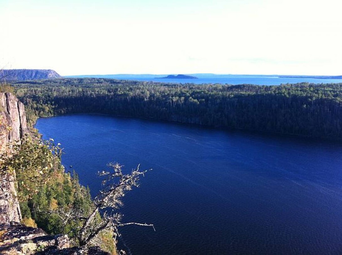
A breathtaking view of Lake Superior at Ruby Lake just east of Nipigon
By Kirsten Spence
Kirsten is a freelance writer living in Northwestern Ontario near the shores of Lake Superior
October 28, 2024
The hike to Ruby Lake, just east of Nipigon, Ontario on the north shore of Lake Superior is a great way to spend an afternoon enjoying the beautiful fall colours while soaking in the amazing views of Lake Superior. So, lace up your hiking boots and make the trip along Lake Superior's north shore east of Thunder Bay to see these great vistas at Ruby Lake with family and friends.
Stand At The Top of Lake Superior
The Anishinabek people refer to Lake Superior as Gitchi Gumme or "The Big Lake". One of the best places to view the Big Lake is in the Nipigon area where some of the best hiking trails are located.
The trail at Ruby Lake Provincial Park is one such trail that delivers stellar views and amazing birding opportunities.
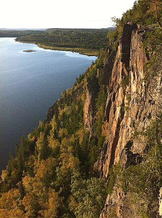
The hiking trail at Ruby Lake Provincial Park is like discovering a hidden gem. Coming through the forest, the trail suddenly opens up offering the most amazing view of Lake Superior with Ruby Lake lying 100' below in the canyon.
It is absolutely breathtaking. If you are a birder, Peregrine Falcons, Redtail Hawks and Bald Eagles are often seen playing in the thermal updrafts along the cliffs. On a recent hike in, we came across a family of Ruffed Grouse who claimed the trail so we were able to walk up quite close before they sprang into flight.
Ruby Lake Provincial Park is a non-operating Natural Environment park established in 2002. The trail is maintained by local volunteers from the Nipgon-Red Rock area, and it offers stunning vistas of Parks Canada's proposed Lake Superior National Marine Conservation Area. On a clear day from this vantage point, hikers have a clear view of La Grange and Vert Islands as well as the town of Red Rock off in the distance.
A Rugged Natural Trail
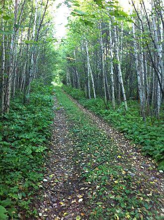
This intermediate level hike is mostly on an abandoned logging road with the last short section of trail being single file with a rugged, natural surface. The last section of trail out to the lookout is marked by a piece of reflective tape around a tree about shoulder high.
The trail is quite defined so one shouldn’t miss it. The trail is roughly 2.3 kms one way and will take about 45 minutes to hike out to the lookout. The trail can be muddy in places and does have steady climbs.
Sturdy footwear and fluids to stay hydrated are strongly recommended. Don’t forget to take your camera!
About 75 minutes east of Thunder Bay, this hike is a great way to spend an afternoon. To access the start of the trail, travel 7.9 kms east of the Nipigon River Bridge on Highway 17.
The road doesn't have a name or a sign but it stands out on the Trans Canada HIghway as the access is on a long straightaway marked by a stop sign (right hand side).
The gravel road takes you into the historic Nipigon River marble quarry about 3.5kms off the highway. Park at the Y in the road and follow the trail up the hill to the right.
Showing 'Edited Body' is no longer supported.
About Kirsten Spence
Kirsten is a freelance writer living in Northwestern Ontario near the shores of Lake Superior where her passion for the outdoors has led to amazing discoveries in the area. Kirsten has worked for many Not-for-Profit trail organizations in Ontario including Trans Canada Trail, The Park-to-Park Trail Association and volunteers with many other regional trail groups to develop trails. She is an avid hiker, beekeeper and gardener amongst many hobbies. Kirsten lives outside of Thunder Bay, ON with her husband Jim on their hobby farm - Hurkett Hill Farm. Her passion for self-sustainability and homesteading has brought back a simpler life of hard work and rewarding lifestyle.