"The Crack" at Killarney Provincial Park
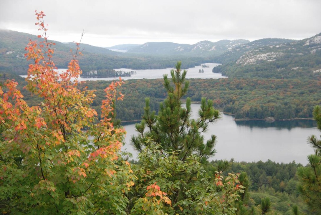
Once higher than the Rocky Mountains, La Cloche’s white quartzite cliffs gleam like snowy peaks from afar. It is only one of the reasons you will want to make this a destination hike.
With an estimated age of 3.5 billion years, the La Cloche Mountains are one of the oldest mountain ranges on Earth and remain among the highest altitudes in Ontario.
The “Crack” itself is a stunning steep sided crevasse slicing through a quartzite rock cliff. It is a gateway to the top thanks to a fault in the Earth’s crust and movement over time.
The legend of the La Cloche Mountains says that these rocks were tocsins (warning bells) used by the First Peoples for signalling. The “Bell Rocks” when struck could be heard for a considerable distance. Hence, the area was named with the French word for “bell” — La Cloche.
Other Legendary Adventures with Backroads Bill
Fall in Love with Killarney and the La Cloche Mountains
Come September, Killarney and the La Cloche Mountains will be ablaze with leaves of flaming golds, pumpkin oranges and candy apple reds. Fall is fast approaching, which means a hike to see the fall colours is in order.
It is after all the perfect time to travel the back roads in search of a legendary adventure.
Nearly a century ago, a group of artists travelled to paint in northern Ontario, and effectively immortalize the beauty that lay just beyond the urban areas. Armed with sketchbooks, brushes, and paint boxes, the Group of Seven set off into the heart of Ontario, to interpret the landscape as a means of artistic expression.
Those same landscapes that the Group of Seven interpreted in the 1920s still exist today, untouched and slightly diversified. It is possible to stand where the individuals of the Group of Seven once stood. Many of the locations are actually within the iconic Killarney Provincial Park.
If the Group of Seven is of particular interest, consider looking into Jim and Sue Waddington's research. The Waddington's have worked hard to photograph the original locations painted by the Group of Seven, and what they found were a mass of iconic northern Ontario landscapes. They can also provide insight into the working methods and distinct personalities of the artists through the circumstances surrounding their trips—climate conditions, the physical challenges faced, methods of travelling and choice of location.
Sleuthing as an Avocation
In July 1977, Jim and Sue Waddington set off on their first expedition to discover the places that inspired the Group of Seven. They were determined to locate, document, and photograph the actual landscapes that inspired , A.Y. Jackson, Franklin Carmichael, Arthur Lismer, Lawren Harris, A.J. Casson, J.E.H. MacDonald and Tom Thomson. Their research is more than an insight in Canadian art history, it is a documented dogged pursuit, braving Canadian backroads and waterways.
For Jim and Sue, travelling and tromping through deep bush for Group of Seven sites was a perfect hobby for an active couple. “Years ago it dawned on us that we never knew exactly where the Group of Seven painted,” says Jim. “We knew they painted in the Canadian North. But where exactly? Each painting was a new puzzle. Sometimes you can get an idea where from the title of a painting. But that often doesn’t help you find the exact spot.”
Some locations were easier to find than others. Typically, the Waddington’s take miniatures of paintings into the area they are exploring. In some cases the landscapes they found revealed few changes.
“We knew this painting” — ‘Twisted Pine’ (1939) by Franklin Carmichael — “which we were sure we’d never see the tree alive,” said Jim. Then someone in the area told them: “We know all about it. Do you want to go and see it?” They did. “It looks very much now as it did then, about two metres high; it hadn’t grown very much at all.”
In 1995, they came across a small boulder they’d seen in a photo of Franklin Carmichael sitting on a rock and sketching high above Grace Lake in the western side of Killarney Provincial Park.
“We knew we had to find and sit on that rock,” says Sue. “It was a fun thought.”
So, they scoured the hills, and found the vista where Franklin Carmichael sat - but no rock. They thought for a moment that they were at the wrong hill. The mystery was only solved when a friend, hiking down the hill, came across the boulder in question. The next year the Waddington’s returned to the area and with friends hauled the rock up the hill by block and tackle.
“Each winter we consider our next trip and what paintings we'd like to search for,” Jim says. “Sue reads up on the area and the artists’ attachment to it and I study the topographic maps.”
Follow in the Footsteps
Where exactly did the Group of Seven paint their magnificent landscapes?
- Click here to dowload the map file
- Click here to download the .KMZ file
- Click here to download the .GPX file
Franklin Carmichael and A.Y. Jackson were inspired by the unique landscape and culture of Sudbury and district basin, including Killarney. Jackson was an important figure in the creation of Killarney and is often affectionately known as the “Father of Killarney Park. The La Cloche Silhouette Trail is Killarney’s only backpacking trail, that leads to The Crack. Named after his painting “La Cloche Silhouette” and the “La Cloche Panorama” this trail is dedicated to the memory of The Group of Seven artist Franklin Carmichael.
To get to the trailhead, drive 32 km south of Sudbury on Highway 69, and turn west on Highway 637. Drive down 'Killarney Highway' 637 for 50 km. The access road is on the right, not far past the roadside picnic area and just inside the Killarney Provincial Park boundary sign. Walk north on the well-marked ‘La Cloche Silhouette Trail (“crack" trail), (just shy of 4 km, one way) into the La Cloche range.
The first part of the trail is an old logging road and is flat; then you climb up and on to the exposed quartzite. You will come to The Crack. Grapple up, and at the top you'll have one of the finest views in Ontario, including many lakes below, rock-knob hilltops, with Georgian Bay in the distance. Here are the coordinates at the top: N46° 03' 42.5" W81° 20' 52.7” or WGS 84 - Zone 17 T 473046 5100925. The entire trek is less than four hours, depending on how many photos you take.
If you are interested in learning more about the Group of Seven's association to Killarney, consider picking up the Waddington’s book; In The Foosteps of The Group of Seven.
If you're planning to visit The Crack this fall, follow the peak colour times at http://www.parkreports.com/fall/. Also, if you're looking for accommodations in the Killarney area, click here.
Recommended Articles
The Seven's Best Hikes, Biking Trails and Lakes

7 Best Spots to Check Out in The Seven

Budget Bliss: Explore Northeastern Ontario Without Breaking the Bank

Bring Your Fam!

Time to Unwind: 6 Spa Havens to Discover In The Seven
5 Amazing Places to SUP in Northeastern Ontario

5 Amazing Bike Rides to Discover

Northern Lights in Northeastern Ontario

Northeastern Ontario's Best Pride Festivals

Fish for one of the World's Rarest Species of Trout

An Insider's Guide to Manitoulin Island

6 Small-Town Gems to Explore in Northeastern Ontario

11 Best Things to Do in Kapuskasing, Ontario


